54°24'55" S
3°19'25" E
~0m asl
( - UTC/GMT+)
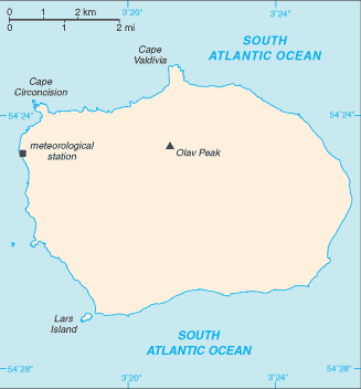
Wilhelmplataet (Wilhelmplatået) est un/une dôme calotte glaciaire (class H - hydrographique) en Bouvetoya (general) (Bouvet Island (general)), Bouvet Island [ Norvège ] (Antarctica), ayant le code de région Americas/Western Europe...
Wilhelmplatået est aussi connu(e) comme Wilhelm II Plateau, Wilhelmplataet, Wilhelmplatået.
Les coordonnées géographiques sont 54°24'55" S et 3°19'25" E en DMS (degrés, minutes, secondes) ou -54.4153 et 3.32361 (en degrés décimaux). La position UTM est EV27 et la référence Joint Operation Graphics est SN31-08.
L’heure locale actuelle est ; le lever du soleil est à 08:54 et le coucher du soleil est à 21:01 heure locale ( UTC/GMT+). Le fuseau horaire pour Wilhelmplataet est UTC/GMT+
En 2024 l’heure d’été est valable de - à -.
A Dôme calotte glaciaire est une zone relativement élevée sur une calotte glaciaire.
|
Advertisements:
Advertisements:
|
Météo Wilhelmplatået (Nébulosité, Température, Vent et Précipitation mm probab.)
Sat
Apr 27
0 °C min
1 °C max
59 km/h
Thu Jan 1
|
Sun
Apr 28
0 °C min
2 °C max
34 km/h
Thu Jan 1
|
Mon
Apr 29
0 °C min
2 °C max
30 km/h
Thu Jan 1
|
Tue
Apr 30
-1 °C min
1 °C max
38 km/h
Thu Jan 1
|
Wed
May 1
0 °C min
2 °C max
33 km/h
Thu Jan 1
|
Thu
May 2
~8 l/m2 70%
1 °C min
2 °C max
41 km/h
Thu Jan 1
|
|
|
Wilhelm II Plateau (Bouvetoya (general)) prévisions à 7 jours
Carte et Les photos Wilhelmplataet
--- Il n'y a aucun commentaire ---
Ajouter un commentaire:
|
Login
Bouvet Island [ Norvège ] (Norway):
Advertisement
Points GPS pres de Wilhelmplatået
Points GPS de Bouvet Island [ Norvège ] (Norway)
|
 Mosby Peak (1 km)